Oneida County Corner Search - Database Viewer

Public Land Survey System (PLSS) Corner ID Explanation

PLSS Corner ID Explanation

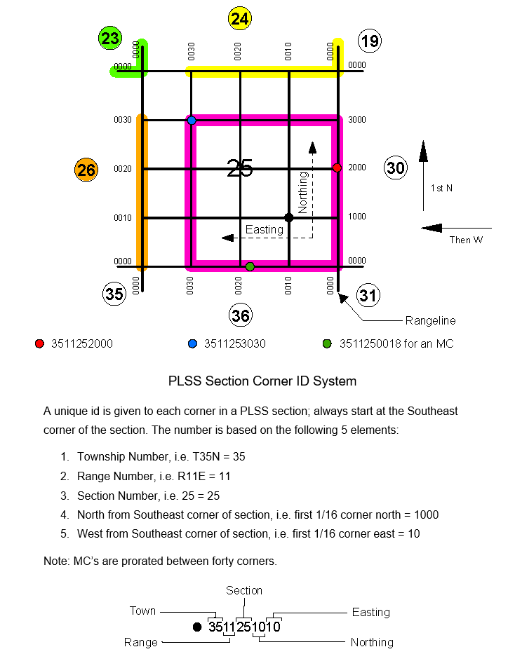
This diagram explains how PLSS corner identification numbers are structured and what each digit represents in the corner ID system used for land surveying records.

Filter Records

Reset Filters

Export Data

📥 Export to CSV Will export all records (5,189 records)

Records

Showing 5151 to 5189 of 5189 records
Town Range Section File
40 08 35 4008350000.pdf
40 08 35 4008350020.pdf
40 08 36 4008360000.pdf
40 08 36 4008360020.pdf
40 09 31 4009310000.pdf
40 09 31 4009310020.pdf
40 09 32 4009320000.pdf
40 09 32 4009320020.pdf
40 09 32 4009320027.pdf
40 09 32 4009320032.pdf
40 09 33 4009330000.pdf
40 09 33 4009330020.pdf
40 09 34 4009340000.pdf
40 09 34 4009340020.pdf
40 09 35 4009350000.pdf
40 09 35 4009350020.pdf
40 09 36 4009360000.pdf
40 09 36 4009360020.pdf
40 10 36 4010360000.pdf
40 11 31 4011310000.pdf
40 11 31 4011310012.pdf
40 11 31 4011310013.pdf
40 11 31 4011310018.pdf
40 11 31 4011310030.pdf
40 11 32 4011320000.pdf
40 11 32 4011320020.pdf
40 11 32 4011320027.pdf
40 11 33 4011330000.pdf
40 11 33 4011330020.pdf
40 11 34 4011340000.pdf
40 11 34 4011340003.pdf
40 11 34 4011340012.pdf
40 11 34 4011340033.pdf
40 11 35 4011350000.pdf
40 11 35 4011350020.pdf
40 11 35 4011350028.pdf
40 11 35 4011350038.pdf
40 11 36 4011360000.pdf
40 11 36 4011360020.pdf